
The Role of Drones in Environmental Conservation: Forget dusty field guides and hours of painstaking fieldwork. A new era of eco-warriors has arrived, buzzing silently on wings of technological innovation. Drones, once synonymous with military operations, are now transforming environmental conservation, offering a bird’s-eye view – literally – of our planet’s most pressing challenges. From tracking endangered species to combating poaching, these unmanned aerial vehicles are revolutionizing how we protect our natural world.
Their versatility is astonishing. Imagine pinpointing illegal logging operations in real-time, assessing the damage from wildfires with unprecedented speed, or monitoring the health of vital ecosystems with detailed spectral imagery. Drones are no longer just a futuristic fantasy; they’re a practical, powerful tool that’s already making a significant impact on conservation efforts worldwide. This isn’t just about efficiency; it’s about enhancing our ability to understand and safeguard the planet’s delicate balance.
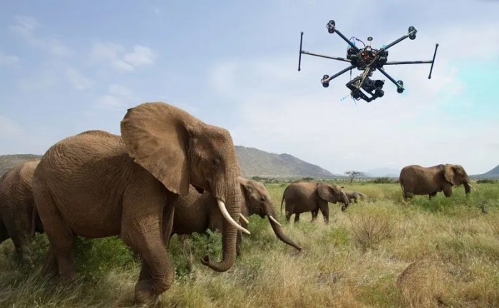
Drones in Wildlife Monitoring and Conservation
The integration of drone technology into wildlife conservation efforts marks a significant leap forward in our ability to understand and protect endangered species. These unmanned aerial vehicles (UAVs) offer unprecedented access to remote and challenging terrains, providing valuable data that was previously difficult or impossible to obtain using traditional methods. This allows for more effective monitoring, targeted interventions, and ultimately, a greater chance of species survival.
Tracking Endangered Species Populations Using Drones
Drones equipped with high-resolution cameras and thermal imaging sensors are revolutionizing how we track endangered species populations. For instance, researchers use drones to monitor nesting sites of critically endangered sea turtles, obtaining detailed counts and assessing the health of nests without disturbing the sensitive animals. Similarly, drones are deployed to track elusive snow leopards in the Himalayas, using thermal imaging to detect their presence even in challenging weather conditions and dense vegetation. By analyzing drone imagery, researchers can accurately estimate population sizes, track individual movements, and identify potential threats to these vulnerable creatures. The data collected helps inform conservation strategies, such as habitat restoration or anti-poaching initiatives.
Advantages of Drone-Based Wildlife Monitoring
Drone-based monitoring offers several advantages over traditional ground-based and aerial surveys. These advantages translate to more efficient data collection, cost savings, and ultimately, more effective conservation outcomes.
| Method | Cost | Accessibility | Data Quality |
|---|---|---|---|
| Ground-Based Surveys | High (labor intensive, time-consuming) | Limited (difficult terrain inaccessible) | Moderate (potential for observer bias) |
| Aerial Surveys (Traditional Aircraft) | Very High (aircraft rental, pilot costs) | Moderate (weather dependent, limited flight time) | Good (wide area coverage) |
| Drone-Based Surveys | Moderate (relatively low operational costs) | High (access to remote and difficult terrain) | Excellent (high-resolution imagery, thermal imaging) |
Assessing Habitat Quality and Identifying Threats Using Drone Imagery
Drone imagery is invaluable in assessing habitat quality and pinpointing threats to wildlife. High-resolution images can reveal habitat degradation, such as deforestation or illegal mining activities, impacting the survival of many species. For example, analysis of drone images can identify areas of illegal logging in rainforest habitats crucial for orangutans, allowing for rapid intervention and enforcement actions. Furthermore, thermal imagery can detect signs of poaching activity, like campfire smoke or unusual heat signatures, providing crucial evidence for law enforcement. By identifying and quantifying these threats, conservationists can develop targeted strategies to mitigate their impact and improve habitat conditions. The detailed and comprehensive data provided by drones empowers conservation efforts with unprecedented precision and efficiency.
Drones for Anti-Poaching Efforts
The fight against poaching is a relentless battle against illegal wildlife trade, threatening biodiversity and ecosystem stability. Traditional methods of anti-poaching patrol are often insufficient to cover vast and remote protected areas. Drones, however, offer a technological advantage, providing a cost-effective and efficient solution to enhance security and deter poaching activities. Their versatility and advanced capabilities are transforming the landscape of wildlife protection.
Drones equipped with high-resolution cameras and thermal imaging technology are revolutionizing anti-poaching strategies. These unmanned aerial vehicles (UAVs) can patrol large areas quickly and discreetly, identifying potential threats and providing real-time information to ground teams. This allows for a more proactive and targeted response to poaching activities, increasing the chances of apprehending poachers and preventing wildlife crimes.
Thermal Imaging Technology for Nighttime Detection
Thermal imaging cameras on drones detect the heat signatures of animals and humans, allowing for effective surveillance even in complete darkness. Poachers often operate under the cover of night to avoid detection, making this technology crucial. The thermal images clearly distinguish warm-blooded animals from their surroundings, enabling rapid identification of potential poachers. This capability significantly enhances the effectiveness of anti-poaching efforts, extending surveillance beyond the limitations of daylight hours. The heat signatures of humans or vehicles stand out vividly against the cooler background, providing clear visual evidence for law enforcement.
Examples of Successful Anti-Poaching Operations Utilizing Drones
The successful integration of drones in anti-poaching initiatives has yielded significant results globally. The use of drones has proven to be instrumental in disrupting poaching operations and improving the safety of park rangers.
- In the Kruger National Park in South Africa, drones equipped with thermal imaging have successfully detected and tracked poachers at night, leading to arrests and the seizure of illegal hunting equipment. The drones’ ability to cover large areas quickly allowed rangers to respond swiftly and effectively.
- In the Democratic Republic of Congo, drones have been used to monitor gorilla populations and identify areas vulnerable to poaching. This information has helped park rangers to allocate resources more effectively and to focus their patrols on high-risk areas.
- In Botswana, drones have been used to patrol vast areas of the Okavango Delta, a crucial habitat for elephants and other wildlife. The drones’ aerial perspective has allowed rangers to identify illegal fishing and hunting activities, leading to increased enforcement and improved protection of the ecosystem.
Drones in Environmental Monitoring and Assessment
Drones, or unmanned aerial vehicles (UAVs), are revolutionizing environmental monitoring and assessment, offering unprecedented capabilities for data acquisition and analysis across vast and often inaccessible areas. Their agility, cost-effectiveness, and advanced sensor technologies allow for detailed observation and measurement, providing crucial information for conservation efforts and environmental management. This section will explore the specific applications of drones in monitoring deforestation, assessing the impact of natural disasters, and evaluating vegetation health.
Monitoring Deforestation and Illegal Logging
Drones equipped with high-resolution cameras and multispectral sensors provide detailed imagery of forested areas, allowing for the precise detection of deforestation and illegal logging activities. The high-resolution images can reveal subtle changes in forest cover, such as the clearing of small patches of trees or the construction of illegal logging roads, which might be missed by traditional methods. Real-time monitoring enables rapid response to illegal activities, facilitating timely intervention by law enforcement and conservation agencies. For example, in the Amazon rainforest, drones are being used to track deforestation rates and identify areas where illegal logging is prevalent, enabling authorities to quickly deploy resources to curb these activities. Analysis of drone imagery can also reveal patterns of deforestation, helping to identify the drivers of deforestation and inform targeted conservation strategies.
Assessing the Impact of Natural Disasters on Ecosystems, The Role of Drones in Environmental Conservation
Drones play a crucial role in assessing the impact of natural disasters such as floods and wildfires on ecosystems. Their ability to access disaster-stricken areas quickly and safely, even in hazardous conditions, allows for rapid damage assessment. High-resolution imagery provides detailed information on the extent of damage to vegetation, infrastructure, and habitats. Thermal imaging capabilities can detect hotspots in wildfires, aiding in fire suppression efforts and assessing post-fire damage. For instance, following a major wildfire, drones can map the extent of burned areas, identify areas where erosion is likely to occur, and assess the impact on wildlife habitats. This information is vital for planning post-disaster recovery and rehabilitation efforts.
| Assessment Method | Advantages | Disadvantages | Example |
|---|---|---|---|
| Drone-based Assessment | Rapid deployment, high-resolution imagery, wide area coverage, cost-effective for large areas, safe access to hazardous areas | Weather dependent, limited flight time, requires skilled operators, data processing can be complex | Post-hurricane assessment of coastal wetlands to determine the extent of saltwater intrusion and habitat loss. |
| Traditional Post-Disaster Assessment | Established methodologies, familiar to stakeholders | Time-consuming, costly, limited access to hazardous areas, potential for human error, limited spatial resolution | Ground surveys following a flood to assess damage to infrastructure and residential areas. |
Monitoring Vegetation Health Using Multispectral and Hyperspectral Imagery
Multispectral and hyperspectral sensors mounted on drones capture images across a range of wavelengths, providing detailed information about the health and condition of vegetation. Different plant species and physiological states reflect light differently at various wavelengths. By analyzing these spectral signatures, we can identify stressed or diseased vegetation, monitor crop health, and assess the overall health of ecosystems.
| Spectral Index | Description | Application in Environmental Monitoring |
|---|---|---|
| NDVI (Normalized Difference Vegetation Index) | (NIR – Red) / (NIR + Red) | Assessing vegetation health, monitoring drought stress, mapping biomass |
| NDWI (Normalized Difference Water Index) | (Green – NIR) / (Green + NIR) | Mapping water bodies, monitoring water stress in vegetation |
| EVI (Enhanced Vegetation Index) | 2.5 * ((NIR – Red) / (NIR + 6 * Red – 7.5 * Blue + 1)) | Improved sensitivity to high biomass areas, reducing saturation effects |
Drones in Precision Agriculture and Sustainable Farming
The agricultural sector is undergoing a significant transformation, driven by the need for increased efficiency, sustainability, and food security. Drones, with their advanced capabilities, are emerging as key players in this revolution, offering innovative solutions for optimizing resource use and improving farming practices. From precision irrigation to targeted pesticide application, drones are reshaping how we cultivate our food, paving the way for a more sustainable and productive future.
Drones are revolutionizing agricultural practices, allowing for data-driven decision-making and contributing significantly to sustainable farming methods. By integrating drone technology, farmers can enhance resource management, reduce environmental impact, and boost overall yields. This transition towards precision agriculture is not just about technological advancement; it’s a fundamental shift towards a more environmentally responsible and economically viable approach to food production.
Drone-Based Precision Irrigation
Precision irrigation, enabled by drones, involves using aerial imagery and sensor data to identify areas in a field that require water. Drones equipped with multispectral or hyperspectral cameras can detect variations in soil moisture content, allowing farmers to target irrigation efforts to specific zones, minimizing water waste and optimizing crop health. This technique is particularly crucial in regions with water scarcity, allowing for efficient resource allocation and increased water-use efficiency. For example, a vineyard in California might use drone-based data to identify which vines are stressed due to lack of water, allowing targeted watering instead of irrigating the entire vineyard. This leads to significant water savings and improved grape yield.
Drone-Based Crop Monitoring for Optimized Pesticide and Fertilizer Use
Drones equipped with high-resolution cameras and multispectral sensors can provide detailed images of crops, allowing farmers to monitor their health and identify problems early on. This real-time monitoring helps detect nutrient deficiencies, pest infestations, or diseases before they spread significantly, allowing for targeted application of pesticides and fertilizers. By applying these inputs only where needed, farmers can reduce the overall amount used, minimizing environmental damage and reducing costs. For instance, a corn farmer in Iowa could use drone imagery to pinpoint areas affected by a fungal disease, applying fungicide only to those affected areas instead of treating the entire field, resulting in significant cost savings and reduced environmental impact.
Comparison of Drone Use in Organic and Conventional Farming
The application of drones in organic and conventional farming presents both similarities and differences. While both approaches benefit from the improved monitoring and resource management capabilities of drones, the specific applications and challenges vary.
| Feature | Organic Farming | Conventional Farming |
|---|---|---|
| Benefits | Improved precision in organic pest and disease management, reduced reliance on broad-spectrum treatments, optimized nutrient application for certified organic inputs. | Increased efficiency in pesticide and fertilizer application, enhanced yield prediction and management, precise monitoring of large-scale operations. |
| Challenges | Stricter regulations regarding approved drone technologies and data processing for organic certification, higher cost of certified organic inputs, potentially higher initial investment in specialized drone technology for organic compliance. | Potential for misuse leading to increased pesticide and fertilizer use if not properly managed, concerns regarding the environmental impact of increased drone operations, data security and privacy concerns. |
Challenges and Limitations of Drone Use in Environmental Conservation
Drones offer incredible potential for environmental conservation, but their adoption isn’t without its hurdles. From ethical dilemmas to technological constraints and regulatory barriers, a range of factors can limit the effectiveness and widespread use of drones in this critical field. Understanding these challenges is crucial for maximizing the benefits of this technology while minimizing its potential drawbacks.
Ethical Considerations in Drone Use for Wildlife
The use of drones in wildlife monitoring raises several ethical questions. Concerns exist about the potential for drone noise and presence to disturb wildlife, impacting their natural behaviors, breeding patterns, and overall well-being. For instance, a study might show increased stress levels in nesting birds due to drone overflights. Another concern revolves around the privacy implications of using drones to observe animals in their natural habitats, particularly in sensitive ecosystems. Striking a balance between data acquisition and minimizing disturbance is a key ethical challenge. The potential for misuse, such as unauthorized surveillance or harassment of animals, also necessitates the development of clear ethical guidelines and responsible operational practices.
Technological Limitations of Current Drone Technology
While drone technology has advanced significantly, several limitations hinder widespread adoption in environmental conservation. Battery life remains a significant constraint, particularly in remote areas requiring extensive flight times. Current drone technology often struggles with operation in challenging weather conditions, like strong winds or heavy rain, limiting data collection opportunities. The payload capacity of many drones also restricts the types and quantity of sensors that can be carried, limiting the scope of data acquisition. Furthermore, image and data processing can be computationally intensive, requiring substantial processing power and expertise. Improving battery technology, enhancing weather resilience, increasing payload capacity, and streamlining data processing are crucial for broader implementation.
Regulatory Hurdles and Legal Frameworks
Navigating the legal and regulatory landscape for drone operation is a significant challenge. The rules governing drone flights vary widely across jurisdictions, often requiring specific permits and licenses. These regulations often involve restrictions on flight altitude, operational areas, and data collection activities.
- Permitting and Licensing: Obtaining necessary permits and licenses can be a time-consuming and complex process, involving various bureaucratic hurdles and potential delays.
- Air Space Restrictions: Many areas, especially near airports or protected zones, have restricted airspace, limiting drone operations.
- Data Privacy and Security: Regulations concerning the collection, storage, and use of data obtained through drones need to be carefully considered to ensure compliance with privacy laws.
- Liability and Insurance: Clear guidelines on liability in case of accidents or damage caused by drones are essential, along with appropriate insurance coverage.
- International Regulations: The lack of harmonized international regulations can create complications for cross-border drone operations in environmental conservation projects.
The complexity of these regulations often requires specialized legal expertise, adding another layer of complexity and cost to drone-based conservation efforts. Standardization and simplification of these regulations are critical for promoting wider adoption of drone technology in environmental conservation.
Future of Drones in Environmental Conservation
The integration of drones in environmental conservation is still in its relatively early stages, yet the potential for transformative impact is immense. Ongoing technological advancements are rapidly expanding the capabilities of these unmanned aerial vehicles (UAVs), promising even more effective and efficient solutions to pressing environmental challenges in the years to come. This section explores the exciting possibilities presented by emerging drone technologies and their envisioned role in shaping a more sustainable future.
The future of drone technology in environmental conservation hinges on several key technological advancements. These innovations are not merely incremental improvements; they represent a paradigm shift in how we monitor, assess, and manage our planet’s resources and ecosystems.
AI-Powered Image Analysis and Autonomous Flight
The synergy between artificial intelligence (AI) and drone technology is revolutionizing environmental monitoring. AI algorithms are increasingly sophisticated in processing drone-captured imagery, allowing for automated identification and quantification of various environmental features. For instance, AI can analyze high-resolution images to detect individual trees in a forest, assess their health, and identify signs of disease or infestation with significantly higher speed and accuracy than manual methods. Autonomous flight capabilities, enabled by advanced GPS and sensor technologies, further enhance efficiency. Drones can now be programmed to fly pre-defined routes, covering vast areas autonomously and collecting data without constant human intervention. This reduces operational costs and allows for more frequent monitoring, crucial for detecting subtle changes in dynamic environments like wetlands or coral reefs. For example, a project in the Amazon rainforest is using AI-powered drones to map deforestation in real-time, allowing for rapid responses to illegal logging activities. This level of precision and speed would be impossible with traditional methods.
Advanced Sensor Integration and Data Fusion
Beyond high-resolution cameras, drones are increasingly equipped with a wider range of sensors. Hyperspectral cameras, for example, can capture data across a much broader spectrum of light, providing insights into the chemical composition of vegetation and soil. LiDAR (Light Detection and Ranging) sensors create detailed 3D models of terrain, crucial for mapping erosion, assessing flood risk, and monitoring changes in elevation. Furthermore, the ability to fuse data from multiple sensors – combining visual imagery with LiDAR data, for instance – creates a more comprehensive understanding of the environment than any single sensor could provide. This integrated approach allows researchers to develop more accurate models for predicting environmental changes and developing effective conservation strategies. A recent study utilized multispectral and thermal drone imagery to monitor the health of endangered sea turtle nesting sites, providing data on nest temperature, vegetation cover, and potential threats.
Miniaturization and Enhanced Accessibility
The ongoing miniaturization of drone technology is making it more accessible and affordable for a wider range of conservation organizations and researchers. Smaller, lighter drones are easier to deploy in challenging terrains and require less infrastructure. This increased accessibility democratizes environmental monitoring, allowing smaller, under-resourced organizations to contribute to global conservation efforts. The development of more robust and durable drones, capable of withstanding harsh weather conditions, further expands their operational range and application in diverse environments. For example, small, lightweight drones are being used in remote mountainous regions to monitor snowpack levels, providing critical data for water resource management.
Predictive Modeling and Conservation Planning
The vast amounts of data collected by drones, combined with advanced analytical techniques, can be used to develop predictive models for environmental change. These models can help anticipate threats, such as wildfires or invasive species outbreaks, allowing for proactive conservation strategies. Drone data can also inform the design and implementation of effective conservation interventions, such as habitat restoration projects or the management of protected areas. For instance, drones equipped with thermal cameras can detect early signs of wildfires, providing crucial time for firefighters to respond and potentially preventing widespread damage. The predictive power of drone technology, coupled with AI-driven analysis, is transforming environmental conservation from a reactive to a proactive approach.
Last Recap: The Role Of Drones In Environmental Conservation
Source: remoteflyer.com
The future of environmental conservation is undeniably intertwined with the continued development and implementation of drone technology. As drone capabilities expand, so too will our ability to effectively monitor, protect, and ultimately, restore our precious ecosystems. The ability to gather real-time data, analyze complex patterns, and respond swiftly to environmental threats is no longer a distant dream. It’s the reality shaping a more sustainable future, one drone flight at a time. The buzz is real, and it’s working wonders for the planet.
Drones are revolutionizing environmental monitoring, offering unparalleled access to remote areas for wildlife tracking and pollution assessment. This precision is mirrored in manufacturing, where advancements in robotics, as detailed in this insightful article on The Role of Robotics in Modern Manufacturing , are driving efficiency and accuracy. Similarly, drone technology’s precision is crucial for effective environmental conservation efforts, leading to more targeted and impactful interventions.