
How Autonomous Drones Are Revolutionizing Disaster Management? It’s not just a catchy headline; it’s the future of disaster response. Forget slow, inefficient relief efforts hampered by impassable terrain and communication blackouts. Imagine a swarm of nimble, AI-powered drones zipping across disaster zones, mapping damage, locating survivors, and delivering vital supplies—all autonomously. This is the reality autonomous drones are creating, a game-changer for how we tackle crises and save lives.
From earthquake-ravaged cities to flood-stricken regions, these unmanned aerial vehicles are proving their worth. Their ability to access hard-to-reach areas, coupled with advanced sensor technology and AI-powered analysis, is transforming search and rescue, damage assessment, and aid delivery. This shift isn’t just about speed and efficiency; it’s about saving precious time in those crucial initial hours and days following a disaster, making the difference between life and death.
The Rise of Autonomous Drones in Disaster Response
For decades, disaster relief efforts have relied heavily on human responders, often facing significant challenges in accessing affected areas quickly and efficiently. The aftermath of hurricanes, earthquakes, and wildfires often leaves behind treacherous landscapes, hindering swift rescue operations and hampering the delivery of essential aid. The limitations of traditional methods, coupled with the increasing frequency and intensity of natural disasters, have created a pressing need for innovative solutions. Enter the autonomous drone – a technological marvel transforming disaster management and offering a promising future for faster, safer, and more effective responses.
The use of drones in disaster relief isn’t entirely new. Initially, remotely piloted drones provided a bird’s-eye view of affected areas, offering valuable situational awareness. However, these systems required skilled operators, limiting their deployment and creating a bottleneck in critical timeframes. The inherent risks associated with manually flying drones in hazardous environments also posed significant challenges.
Technological Advancements Enabling Autonomous Drone Operation
Several key technological breakthroughs have propelled autonomous drones to the forefront of disaster response. Advanced GPS and sensor technologies, coupled with sophisticated algorithms for navigation and obstacle avoidance, enable drones to operate independently, navigating complex and unpredictable terrains with minimal human intervention. Computer vision systems allow drones to identify damaged structures, locate survivors, and assess the extent of destruction with remarkable accuracy. Furthermore, improvements in battery technology extend flight times, allowing drones to cover larger areas and perform more extensive surveys. The integration of artificial intelligence (AI) further enhances capabilities, enabling drones to make real-time decisions, adapt to changing circumstances, and even perform tasks like delivering small payloads autonomously. For example, AI-powered drones can autonomously search for survivors in collapsed buildings by analyzing thermal images and identifying heat signatures.
Search and Rescue Operations
Autonomous drones are rapidly transforming search and rescue (SAR) operations, offering unprecedented capabilities in locating survivors in the aftermath of natural disasters and other emergencies. Their ability to access difficult-to-reach areas quickly and efficiently, coupled with advanced sensor technologies, makes them invaluable tools for first responders.
The use of autonomous drones in SAR significantly improves the speed and effectiveness of locating survivors trapped in collapsed structures. Traditional methods often rely on painstaking manual searches, which can be slow, dangerous, and sometimes ineffective. Drones, however, can quickly survey large areas, identifying potential locations of survivors based on visual or thermal signatures. This allows rescue teams to prioritize their efforts and focus resources where they are most needed, potentially saving lives.
Advantages of Drones over Manned Aircraft in Aerial Surveillance
Compared to manned aircraft, autonomous drones offer several key advantages in disaster zone surveillance. Drones are significantly cheaper to operate, requiring less fuel and no pilot salary. They can also access smaller, more confined spaces that are inaccessible to larger aircraft, navigating through rubble and debris with greater agility. Their smaller size also reduces the risk of further damage to already precarious structures. Finally, drones can be deployed much more rapidly than manned aircraft, a critical factor in time-sensitive SAR operations.
Effectiveness of Different Drone Sensor Technologies in Search and Rescue
Different sensor technologies offer unique capabilities in SAR operations. Visual sensors provide high-resolution images, useful for identifying structural damage and potential escape routes. Thermal sensors detect heat signatures, which can pinpoint survivors trapped under debris, even if they are hidden from view. LiDAR (Light Detection and Ranging) creates detailed 3D maps of the disaster area, allowing rescuers to understand the terrain and identify potential access points. The optimal choice of sensor depends on the specific circumstances of the disaster and the information needed by rescue teams. Often, a multi-sensor approach is most effective, combining the strengths of each technology.
Hypothetical Earthquake Rescue Operation
Imagine a major earthquake strikes a densely populated city. Multiple buildings have collapsed, trapping an unknown number of survivors. Autonomous drones are immediately deployed to assess the situation. The drones, equipped with a variety of sensors, systematically survey the affected areas, creating detailed 3D maps and identifying potential survivor locations based on thermal signatures and visual cues. The information gathered is relayed in real-time to rescue teams, allowing them to prioritize their efforts and effectively allocate resources. This coordinated effort significantly increases the chances of rescuing survivors quickly and safely.
| Drone Model | Sensor Type | Task | Flight Time |
|---|---|---|---|
| DJI Matrice 300 RTK | Visual, Thermal, LiDAR | Initial area survey, 3D mapping, survivor location identification | 50 minutes |
| Autel EVO II Dual 640T | Thermal, Visual | Detailed inspection of specific collapsed buildings, confirmation of survivor locations | 40 minutes |
| Parrot ANAFI USA | Visual, Zoom Camera | Close-range inspection of potential access points, relaying real-time video to rescue teams | 30 minutes |
Assessment and Damage Evaluation: How Autonomous Drones Are Revolutionizing Disaster Management
Source: tildacdn.one
Autonomous drones are game-changers in disaster management, providing real-time aerial surveys and crucial data for rescue efforts. Understanding this flood of information, however, requires powerful tools; that’s where the magic of data visualization comes in. Check out this article on The Role of Data Visualization in Understanding Complex Information to see how it helps. Ultimately, visualizing drone data allows for quicker, more effective disaster response, saving lives and resources.
Autonomous drones are rapidly transforming post-disaster assessment, offering a speed and precision previously unimaginable. Their ability to access hard-to-reach areas and capture high-resolution imagery provides invaluable data for understanding the full extent of damage and guiding effective relief efforts. This detailed information is crucial for efficient resource allocation, minimizing loss of life, and accelerating the recovery process.
Drones equipped with advanced sensors can create incredibly detailed 3D maps of disaster-affected areas. This is achieved through a process called photogrammetry, where numerous overlapping images taken from various angles are stitched together using specialized software to create a three-dimensional model. The resulting maps offer a bird’s-eye view, showcasing the precise location and extent of damage to infrastructure, buildings, and landscapes. This level of detail is simply unattainable through traditional ground-based surveys, especially in the immediate aftermath of a disaster when access may be severely limited.
3D Mapping of Disaster Zones
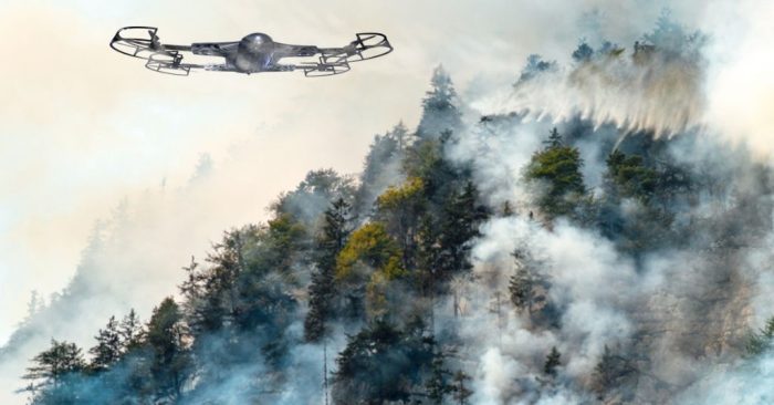
The creation of detailed 3D models is achieved through sophisticated software that processes the vast amounts of data collected by the drone’s cameras. These models aren’t just static images; they can be interactively explored, allowing responders to virtually “walk” through the affected area and assess damage from various perspectives. Imagine a flood-ravaged town: a 3D model allows emergency responders to quickly identify which houses are still structurally sound and which need immediate attention, prioritizing rescue and relief efforts. Similarly, in the aftermath of a wildfire, a 3D map can pinpoint areas where the fire has caused the most damage, guiding firefighting crews to hotspots and enabling assessment of the risk of further spread.
Drone-Based Damage Assessments in Various Disaster Scenarios
Autonomous drones have proven their worth in diverse disaster scenarios. Following Hurricane Maria in Puerto Rico, drones provided crucial data on the extent of infrastructure damage, enabling aid organizations to target their resources effectively. Similarly, in the wake of wildfires in California, drones mapped burned areas, aiding in the assessment of property damage and the identification of areas requiring immediate reforestation efforts. Flood assessments in Bangladesh have utilized drone imagery to quickly identify affected communities and assess the extent of inundation, informing the deployment of rescue boats and relief supplies.
AI-Powered Image Analysis for Damage Quantification
The sheer volume of data collected by drones necessitates the use of artificial intelligence (AI). AI-powered image analysis algorithms can automatically identify and classify damage types, such as collapsed buildings, flooded areas, or damaged roads. This automated process significantly speeds up the assessment process, reducing the time it takes to gather critical information. For instance, AI can be trained to recognize specific damage patterns in buildings, automatically classifying the level of damage as minor, moderate, or severe, which is crucial for prioritizing repair efforts. This automated classification allows for efficient resource allocation and informed decision-making during the recovery phase.
Data-Driven Resource Allocation for Relief Efforts
The data gathered by drones isn’t just useful for assessing damage; it’s instrumental in guiding resource allocation during relief efforts. By identifying the areas most severely affected, emergency responders can prioritize the delivery of essential supplies, medical assistance, and rescue teams. For example, a drone-generated map showing the location of trapped individuals after an earthquake can guide rescue teams directly to those in need, maximizing the chances of survival. Similarly, data on the extent of infrastructure damage can inform the prioritization of road repairs, power restoration, and the distribution of food and water, significantly improving the efficiency of the relief operation. This data-driven approach ensures that resources are deployed where they are needed most, maximizing their impact and accelerating the recovery process.
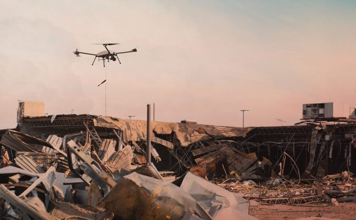
Delivery of Aid and Supplies
Delivering aid after a disaster is a logistical nightmare, especially in remote or hard-to-reach areas. Roads might be destroyed, bridges collapsed, and communication networks severed, leaving vulnerable populations isolated and desperately in need. Traditional methods, like trucking or even helicopters, often struggle to reach those who need help most quickly and efficiently, leading to delays that can cost lives. This is where autonomous drones are stepping in, offering a revolutionary solution.
Autonomous drones are transforming disaster relief by providing a rapid and flexible method for delivering essential supplies. Their ability to navigate challenging terrains and reach areas inaccessible to traditional vehicles makes them uniquely suited for this critical task. This capability is significantly enhancing the speed and effectiveness of humanitarian aid delivery.
Autonomous Drone Delivery Systems and Examples
Several companies and organizations are developing and deploying autonomous drone delivery systems for disaster relief. For instance, Zipline, a company known for its medical drone delivery network in Rwanda, has adapted its technology to deliver emergency supplies in disaster zones. Their drones can carry substantial payloads of medical supplies, food, and water over significant distances, autonomously navigating to pre-programmed drop-off points. Other organizations are exploring the use of larger, heavier-lift drones capable of carrying even more substantial aid packages. These systems often utilize GPS, advanced sensors, and sophisticated flight control algorithms to ensure safe and accurate delivery, even in challenging weather conditions.
Efficiency and Cost-Effectiveness of Drone Delivery
Compared to traditional methods, drone delivery offers significant advantages in terms of both efficiency and cost-effectiveness. Drones can reach disaster-stricken areas much faster than ground vehicles, especially when roads are impassable. They also require less infrastructure and personnel than traditional delivery methods, reducing overall costs. While the initial investment in drone technology might be high, the long-term cost savings and increased efficiency can be substantial, particularly in large-scale disasters. A study by the World Bank, for example, estimated that drone delivery could reduce the cost of delivering vaccines by up to 60% in some regions. This cost-effectiveness is amplified in disaster situations where time is of the essence.
Autonomous Drone Package Drop-Off System Design
Designing a robust and reliable autonomous drone package drop-off system requires careful consideration of several critical factors. Here are some key design considerations and specifications:
- Weight Limits: The maximum weight capacity of the drone must be carefully determined based on the types and quantities of supplies to be delivered. This will also influence the drone’s size and battery life.
- Terrain Navigation: The system must incorporate advanced terrain mapping and avoidance capabilities to navigate challenging landscapes, including mountainous regions, dense forests, and flooded areas. This might involve using LiDAR or other advanced sensor technologies.
- Wind Conditions: The drone’s design and control algorithms should be robust enough to handle varying wind speeds and directions. This might involve using specialized aerodynamic designs or employing sophisticated wind compensation algorithms.
- Drop-Off Mechanism: A reliable and safe package drop-off mechanism is crucial. This could involve a parachute system for heavier packages or a precise lowering mechanism for delicate supplies. The system should minimize the risk of damage to the package during delivery.
- Communication System: A reliable communication system is essential for real-time monitoring and control of the drone. This might involve using cellular networks, satellite communication, or a combination of both.
- Emergency Procedures: The system should include built-in emergency procedures to handle unexpected situations, such as loss of communication or malfunction of the drone. This might involve automated return-to-base capabilities or emergency landing procedures.
- Payload Security: Measures must be in place to ensure the security of the delivered supplies, protecting them from theft or damage during transit. This could involve secure packaging, tamper-evident seals, or even GPS tracking of the package after delivery.
Communication and Connectivity
Maintaining reliable communication in disaster zones is paramount for effective rescue and recovery operations. The destruction of existing infrastructure often leaves emergency responders isolated and unable to coordinate efforts effectively. Autonomous drones, however, offer a crucial solution by providing a flexible and resilient communication platform in the face of chaos.
Autonomous drones leverage a variety of communication technologies to overcome the challenges of damaged infrastructure and ensure seamless data transmission. These technologies enable real-time information sharing between drones, ground control stations, and emergency response teams, significantly enhancing situational awareness and operational efficiency.
Communication Technologies Used by Autonomous Drones
Several communication technologies are employed by autonomous drones operating in disaster zones. These technologies are selected based on the specific needs of the mission, considering factors like range, bandwidth, and the availability of infrastructure. Common methods include line-of-sight radio frequency (RF) communication, cellular networks (4G/5G), satellite communication, and mesh networking. The choice often involves a combination of these technologies for redundancy and robustness. For example, a drone might use a cellular connection when available, switching to satellite communication in areas with limited or no cellular coverage. Mesh networking allows drones to relay information to each other, expanding the communication range and overcoming obstacles.
Establishing Communication Networks in Damaged Infrastructure Areas
Drones can play a crucial role in establishing ad-hoc communication networks in areas where existing infrastructure has been severely damaged or destroyed. Their ability to fly over affected areas and establish temporary communication links is particularly valuable. For instance, a swarm of drones equipped with mesh networking capabilities could create a temporary network covering a large area, allowing emergency responders to communicate with each other and with the outside world. This is particularly important in situations where traditional communication infrastructure, such as cell towers and landlines, has been compromised. This capability is especially useful in remote or geographically challenging areas where establishing traditional communication infrastructure would be costly and time-consuming.
Relaying Real-Time Information to Emergency Responders, How Autonomous Drones Are Revolutionizing Disaster Management
The real-time data transmission capability of autonomous drones is a game-changer in disaster management. Equipped with high-resolution cameras, thermal imaging sensors, and other advanced sensors, drones can capture and transmit crucial information about the disaster’s extent and impact. This real-time information stream allows emergency responders to make informed decisions, prioritize rescue efforts, and allocate resources effectively. For example, a drone equipped with thermal imaging could locate survivors trapped under debris, while another drone could assess the extent of structural damage, informing the deployment of rescue teams and heavy equipment. The speed and efficiency gained through this real-time information flow can significantly improve the effectiveness of disaster response efforts.
Communication Process Flowchart
The communication process typically involves a three-way interaction: the autonomous drone, the ground control station, and the emergency response teams. Imagine a flowchart with three main boxes representing these three entities. Arrows would show the flow of information. The drone collects data (images, sensor readings, etc.) and transmits this data to the ground control station via a chosen communication method (e.g., RF, cellular, satellite). The ground control station processes the data, generating a comprehensive picture of the disaster situation. Finally, the ground control station relays this processed information to the emergency response teams, who use it to guide their actions. This continuous loop of data collection, processing, and dissemination ensures a dynamic and responsive disaster management operation.
Ethical and Regulatory Considerations
The increasing autonomy of drones used in disaster relief presents a complex interplay of benefits and potential pitfalls. While these unmanned aerial vehicles offer unparalleled speed and efficiency in delivering aid and assessing damage, their use raises significant ethical and regulatory questions that demand careful consideration. Balancing the urgency of disaster response with the need for responsible technological deployment is crucial to ensure both effectiveness and ethical conduct.
The integration of autonomous systems into disaster management necessitates a robust framework that addresses potential ethical dilemmas and establishes clear operational guidelines. This framework must account for the unique challenges posed by these technologies, ranging from data privacy concerns to the potential for unintended consequences. A proactive approach to regulation is essential to foster public trust and maximize the positive impact of autonomous drones in disaster relief efforts.
Ethical Dilemmas in Autonomous Drone Deployment
Deploying autonomous drones in disaster zones inevitably brings ethical challenges. For example, algorithmic decision-making in search and rescue operations might prioritize certain individuals over others based on pre-programmed parameters, potentially leading to unfair or discriminatory outcomes. Similarly, the collection and use of sensitive data captured by drones raise privacy concerns, particularly in the context of vulnerable populations affected by disasters. Another critical aspect is the potential for algorithmic bias in the assessment of damage and allocation of resources, which could inadvertently exacerbate existing inequalities. Transparency in the decision-making processes of autonomous drones is therefore crucial to build public trust and ensure equitable resource allocation. The potential for malfunction or unintended consequences also necessitates rigorous testing and fail-safes to minimize harm.
Existing Regulations and Guidelines
Currently, the regulatory landscape for drone operation varies significantly across countries. Many nations have established national aviation authorities that oversee the use of drones, including those deployed in emergency situations. These regulations typically cover aspects such as registration, licensing, operational limitations (flight altitudes, airspace restrictions), and data privacy. However, the rapid technological advancements in autonomous drone technology often outpace regulatory frameworks, creating a need for continuous adaptation and harmonization of regulations. Existing guidelines often focus on manned drone operations, lacking the specific provisions needed for autonomous systems with their unique operational capabilities and complexities.
Best Practices for Responsible Drone Operation in Disaster Zones
Responsible drone operation in disaster zones requires a multi-faceted approach. Prioritizing human safety is paramount, with strict adherence to all applicable regulations and guidelines. This includes obtaining necessary permissions and approvals before deployment, ensuring compliance with airspace restrictions, and implementing robust safety protocols to mitigate risks. Data privacy and security are also critical concerns. Operators should adhere to strict data protection measures, anonymizing personal information whenever possible and securing data against unauthorized access or breaches. Furthermore, transparency and accountability are essential. Detailed operational logs should be maintained, and mechanisms for independent oversight and review of drone operations should be established. Finally, collaboration with local communities and authorities is crucial to ensure the responsible and ethical use of autonomous drones in disaster response.
International Collaboration for Standardized Regulations
The need for international collaboration in establishing standardized regulations for autonomous drone deployment is undeniable. The global nature of many disasters necessitates a coordinated and harmonized approach to drone operations across borders. Inconsistencies in regulations can hinder effective disaster response, as drones may be restricted in certain areas while freely operating in others. International collaboration can facilitate the development of common safety standards, data protection protocols, and ethical guidelines, ensuring consistent and effective deployment of autonomous drones in disaster relief efforts. This collaboration should involve not only governments and regulatory bodies but also drone manufacturers, operators, and humanitarian organizations to ensure a comprehensive and practical framework that promotes both innovation and responsible technological deployment.
Future Trends and Developments
The future of autonomous drones in disaster management is bright, fueled by rapid advancements in technology and a growing understanding of their potential. We’re moving beyond simply deploying drones; we’re entering an era of sophisticated, adaptable systems capable of handling increasingly complex scenarios. This evolution hinges on several key technological and strategic developments.
The integration of artificial intelligence (AI) and machine learning (ML) is poised to revolutionize autonomous drone capabilities. These technologies will allow drones to make more informed decisions in real-time, adapting to changing conditions and minimizing human intervention. For example, AI-powered image recognition can rapidly assess damage to infrastructure, identify survivors trapped in debris, and even navigate complex terrains autonomously. This level of intelligence will significantly improve the speed and efficiency of disaster response.
Enhanced Drone Capabilities Through AI and Machine Learning
AI and ML are not just enhancing existing drone functionalities; they are creating entirely new possibilities. Advanced algorithms are being developed to enable drones to perform tasks previously impossible, such as predicting the trajectory of a wildfire based on wind patterns and fuel conditions, or autonomously coordinating with other drones to cover a wider search area. This synergy between AI and autonomous flight will lead to faster, more accurate, and more effective disaster relief operations. Imagine a swarm of drones working collaboratively to map a flooded area, identify survivors, and deliver life-saving supplies – all without direct human control.
Ongoing Research and Development in Drone Technology
Significant research and development efforts are focused on overcoming current limitations of autonomous drones. Improving drone endurance is crucial for extended missions in remote or disaster-stricken areas. Researchers are exploring new battery technologies, more efficient propulsion systems, and even solar-powered drones to achieve longer flight times. Similarly, increasing payload capacity is vital for delivering larger quantities of aid and supplies. Engineers are working on designs that can carry heavier loads without compromising maneuverability or flight stability. Simultaneously, advancements in autonomous navigation and obstacle avoidance are critical to ensuring safe and effective operation in unpredictable environments. For example, the development of advanced sensor systems that can accurately detect and avoid obstacles in low-visibility conditions, such as smoke or dense fog, is a significant area of focus.
The Future Role of Autonomous Drones in Disaster Management
Autonomous drones are predicted to play an increasingly central role in disaster management in the coming decades. They will transition from being a supplementary tool to becoming an integral part of emergency response strategies. We can anticipate a future where swarms of drones are deployed proactively to monitor high-risk areas, providing early warning systems for potential disasters. During emergencies, they will rapidly assess the extent of damage, guide rescue teams, deliver essential supplies, and provide critical communication links in areas where traditional infrastructure has been destroyed. This proactive and integrated approach will drastically reduce response times, save lives, and minimize the long-term impact of disasters.
Key Technological Advancements for Disaster Relief in the Next Decade
The next decade promises significant breakthroughs that will revolutionize the deployment of autonomous drones in disaster relief.
- Advanced AI-powered situational awareness: Drones will be able to process vast amounts of data from multiple sensors (visual, thermal, LiDAR) to create a comprehensive understanding of the disaster zone, identifying critical needs and prioritizing responses.
- Enhanced swarm intelligence: Drones will collaborate effectively in large swarms, coordinating their actions to cover large areas, share data, and complete complex tasks autonomously.
- Improved communication and networking: Robust, resilient communication networks will allow drones to maintain constant connectivity with ground control and each other, even in areas with limited or damaged infrastructure.
- Hybrid propulsion systems: Combining electric motors with alternative energy sources like solar power will drastically extend drone endurance, enabling longer missions and broader coverage.
- Autonomous base stations: Self-deploying and self-sustaining base stations will allow for rapid drone deployment and operation in remote locations without requiring significant human infrastructure.
Closing Summary
Source: zenadrone.com
The integration of autonomous drones into disaster management is no longer a futuristic fantasy; it’s a rapidly evolving reality. As technology advances, we can anticipate even more sophisticated applications, further enhancing our ability to respond effectively to natural disasters and humanitarian crises. The future of disaster relief is airborne, autonomous, and undeniably more efficient—a future where technology empowers humanity to overcome even the most devastating challenges. The potential for saving lives and mitigating damage is immense, promising a safer and more resilient world for all.